


The Nevada Test Site (NTS) is located in Nye County in southern Nevada; the southernmost point of the NTS is about 65 miles (105 kilometers) northwest of Las Vegas. The site contains 1,350 square miles (3,500 square kilometers) of federally owned land with restricted access, and varies from 28-35 miles (45-56 kilometers) in width (east-west) and from 40-55 miles (64-88 kilometers) in length (north-south).
The Nevada Test Site is bordered on three sides by 4,120 square miles (10,700 square kilometers) of land comprising the Nellis Air Force Range (NAFR), another federally owned, restricted area. This restricted area provides a buffer zone to the north and east between the test area and land that is open to the public, and varies in width from 15-65 miles (24-105 kilometers). A northwestern portion of the Nellis Air Force Range is occupied by the Tonopah Test Range, an area of 624 square miles (1,620 square kilometers), which is operated for the U.S. Dept. of Energy (DOE) by the Sandia Laboratories primarily for airdrop tests of ballistic shapes for nuclear weapons. The combination of the Tonopah Test Range, the Nellis Air Force Range, and the Nevada Test Site is one of the largest unpopulated land areas in the United States, comprising some 5,470 square miles (14,200 square kilometers).
From the end of World War II until 1951, five U.S. nuclear weapons tests were conducted at distant islands in the Pacific Ocean: two at Bikini atoll and three at Enewetak atoll. Testing at those sites required an extensive logistic effort and an inordinate amount of time. When the decision to accelerate the development of nuclear weapons was made in the late 1940s in response to national defense policy, it became apparent that weapons development lead times would be reduced and considerably less expense incurred if nuclear weapons, especially the lower yield weapons, could be tested safely within the continental boundaries. In addition security of the test operation could be ensured, a considerable concern at a time that a major land war was raging in Asia, and the possibility of direct conflict with China and the Soviet Union was feared.
Accordingly, a number of sites throughout the continental United States, including Alaska, were considered on the basis of low population density, safety, favorable year-round weather conditions, security, available labor sources, reasonable accessibility including transportation routes, and favorable geology. After review of known information about fallout, thermal, and blast effects, it was determined that an area within what is now the Nellis Air Force Range could be used for relatively low-yield nuclear detonations. The Southern Nevada site was selected from a list of five possibilities which included Alamogordo/White Sands, New Mexico; Dugway Proving Ground, Utah; Pamilco Sound/Camp Lejuene, North Carolina; and a 50-mile-wide strip between Fallon and Eureka, Nevada. Although the NTS originally was selected to meet criteria for atmospheric tests, it subsequently also was used for underground tests.
President Harry S. Truman approved the establishment of the NPG on 11 January 1951, and on 27 January 1951 the first atmospheric test was detonated at 1,060 feet above the surface of Frenchman Flat. Public Land Order 805, dated 19 February 1952, identified 680 square miles (1,800 square kilometers) for nuclear testing purposes from an area used by the Air Force as a bombing and gunnery range; this area now comprises approximately the eastern half of the present Nevada Test Site. The predominant geological features of this area are the closed drainage basins of Frenchman Flat and Yucca Flat where the early atmospheric tests were conducted. The main Control Point has remained on the crest of Yucca Pass between these two basins. Additional land was added to the site in 1958, 1961, 1964, and 1967, thereby enlarging the site to its present size of about 1,350 square miles (3,500 square kilometers).
The first true underground test of a nuclear explosive, with the blast entirely contained underground, was the 1.7 kt Plumbob Rainier (16:59:59.5 19 September 1957 at Area 12 of NTS). Operation Nougat (September 1961 - April 1962) was the first test series to be conducted underground. After 1962 no further atmospheric testing was conducted, and all tests henceforth were underground tests.
Although underground testing was the rule after August 1963, it is not exactly true that no radioactivity was released into the atmosphere after that date. First, there were five Plowshare cratering tests conducted underground, but designed to breach the surface (see below). These released a total of 984 kilocuries of I-131 (radioiodine) into the atmosphere. Containment failures for for a few dozen other tests that were supposed to be entirely underground released another 123 kilocuries (two-thirds of this was due to Baneberry, with Des Moines, and Bandicoot accounting for nearly all of the rest). For comparison, Trinity released about 3200 kilocuries of radioiodine. The total population exposure to radioiodine from all 'underground' tests amounted to 9.1 million person-rads of thryoid tissue exposure (about 2% of all exposure due to continental nuclear tests). This can be expected to eventually cause about 2800 cases of thyroid cancer, leading to some 140 deaths. Chart of fallout exposures from "underground tests" (63 K, 539x577). From National Cancer Institute Study Estimating Thyroid Doses of I-131 Received by Americans From Nevada Atmospheric Nuclear Bomb Test, 1997. To go to the National Cancer Institute and get the full report, click here.
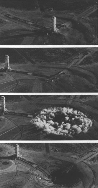
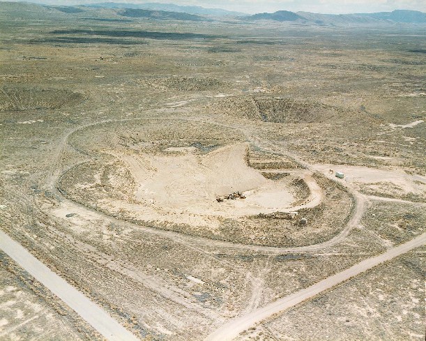
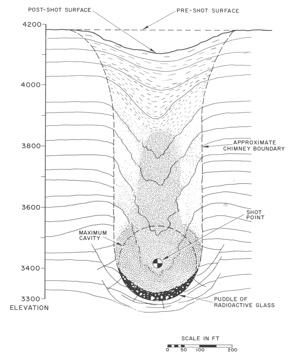
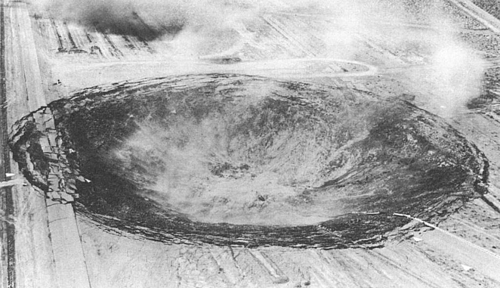
Underground testing often leaves visible evidence on the surface in the form of subsidence craters (more accurately called 'sinks'). These are depressions on the surface that come about when the roof of the blast cavity collapses in to the void left by the explosion. This creates a new roof, which can also shear off into the new, larger, but partially rubble-filled cavity. A chain reaction of successive roof collapses forms a "chimney" that works its way to the surface.
This photo sequence (taken by a circling helicopter) shows the after effects of an underground test. In the first frame (one minute after the test) dust suspended in the air by the shock wave can be seen (with difficulty). The 100 foot shot observation tower then moves back to a safe distance from the center of the shot. At 23 minutes after the test, the surface of the ground caves in to form a crater.
 33 K |
 669x800, 62K; 1003x1200, 120K |
 661x768, 30K |
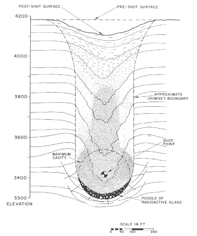
| Subsidence Crater Formation at NTS | Subsidence Crater Cross-section in Alluvium. [Teller et al 1968; p. 140] |
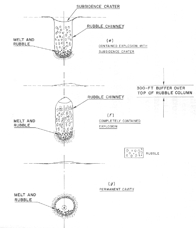
Formation of a Subsidence Crater [Teller et al 1968; p. 128] |
See The Effects of Underground Explosions for more information.
| Test Series | Test Name | Time and Date (GMT) | Location | Test Type | Height (m) | Yield (kt) | Sponsor | Purpose | Comments |
|---|---|---|---|---|---|---|---|---|---|
| Nougat | Danny Boy | 18:15 5-Mar-62 (GMT) | NTS Area Area 18a | Shaft | -34 m | 0.42 | DOD | Weapons Effects (Non-plowshare) | Explore cratering mechanics in hard, dry rock (basalt); 81 m (265 ft) wide crater, 26 m (84 ft) deep |
| Whetstone | Sulky | 19:35 18-Dec-64 (GMT) | NTS Area 18d | Shaft | -27.1 m | 0.092 | LLNL | 11th Plowshare | Explore cratering mechanics in hard, dry rock (granite) and study dispersal pattern of airborne radionuclides; produced a permanent "retarc" (inverted crater); released 13 kilocuries of I-131 |
| Whetstone | Palanquin | 13:14.00.11 14-Apr-65 (GMT) | NTS Area 20k | Crater | -85.7 m | 4.3 | LLNL | 12th Plowshare | Explore cratering mechanics in hard, dry rock (rhyolite) and study dispersal pattern of airborne radionuclides; crater produced was 240 feet by 70 feet; released 910 kilocuries of I-131 |
| Crosstie | Cabriolet | 16:00.00.11 1-Jan-68 (GMT) | NTS Area 20l | Crater | -20 m | 2.3 | LLNL | 20th Plowshare | Study effects and phenomenology of cratering in hard rock (rhyolite); optimum depth of burial for cratering; crater produced was 360 feet by 120 feet; released 6 kilocuries of I-131 |
| Crosstie | Buggy | 17:04.00.11 12-Mar-68 (GMT) | NTS Area 30 | Shaft | -40 m | 5.4 | LLNL | 21st Plowshare | Trench cratering experiment, five 1.1 kt charges detonated 150 feet apart, produced crater 850 ft long, 250 ft wide, and 65 ft deep; released 40 kilocuries of I-131 |
| Bowline | Schooner | 16:00.00.14 8-Dec-68 (GMT) | NTS Area 20u | Crater | -100 m | 30 | LLNL | 23rd Plowshare | Study effects and phenomenology of cratering in hard rock (tuff); crater produced was 800 feet by 270 feet; probably used tungsten-rhenium alloy fission tamper, U-235 core (based on radioisotope releases), released 15 kilocuries of I-131 |
| Test: | Sulky |
|---|---|
| Time: | 19:35 18 December 1964 (GMT) |
| Location: | NTS Area 18d |
| Test Height and Type: | Shaft, -27.1 m |
| Yield: | 0.092 kt |
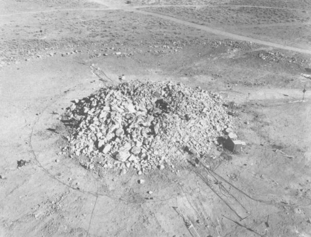
This was the 11th Plowshare shot and was conducted by LLNL. Sulky was fired to explore cratering mechanics in hard, dry rock and to the study dispersal pattern of airborne radionuclides. Sulky was fired in granite strata overlaid with basalt. To the surprise of the test designers, who had expected a depression,it produced a permanent rubble mound called a "retarc" (an inverted crater - the word is "crater" spelled backwards). Permanent retarcs of this kind are restricted to hard rock where the shock displaced material, which has three times the volume of the original strata, is strong enough not to undergo compaction and subsidence. Strong rock like granite is especially conducive to this, since it tends to fracture in large blocks for maximum bulking effect. Sulky was in fact the only retarc producing event in the history of US nuclear testing. The mound was 24 m wide and 6 m high, and had a small depression in the center (9 x 3.5 m). Sulky released 13 kilocuries of I-131.
| Test: | Buggy |
|---|---|
| Time: | 17:04.00.11 12 March 1968 (GMT) |
| Location: | NTS Area 30 |
| Test Height and Type: | Shaft, -40 m |
| Yield: | 5.4 kt |
This was the 21st Plowshare shot. Buggy was a trench cratering experiment and so was not expected to fully contain the radioactive products. Five 1.1 kt charges were detonated 150 feet apart, produced crater 850 ft long, 250 ft wide, and 65 ft deep. It released 40 kilocuries of I-131.
| Test: | Baneberry |
|---|---|
| Time: | 15:30.00.20 18 December 1970 (GMT) |
| Location: | NTS, Area 8d |
| Test Height and Type: | Shaft, -910 Feet |
| Yield: | 10 kt |
Not all underground tests have successfully contained the radioactive products. In Baneberry, failure of the stemming and capping of the shaft allowed a radioactive jet to emerge. Radioactivity was detected off site (i.e. outside the Nevada Test Site). The release of 80 kilocuries of I-131 was by far the worst accidental release at NTS. This was an LLNL weapon related test. For anyone interested in numerology, this was the 666th U.S. test by official count.
| Test: | Huron King |
|---|---|
| Time: | 15:10.00.74 24 June 1980 (GMT) |
| Location: | NTS |
| Test Height and Type: | Shaft, -1050 Feet |
| Yield: | <20 kt |
This was a DOD weapon effects test, part of an Air Force, Defense Nuclear Agency and National Security Agency program to improve the database on nuclear hardening design techniques for satellites. This was a vertical line-of-sight (VLOS) test, a very unusual type of test, using a small DSCS-III satellite prototype. Cost $10.3 million.
The VLOS design involved placing the nuclear device at the bottom of the shaft with the communications satellite and other experiments in an above-ground test chamber to simulate a space environment. At zero time, the radiation from the device flowed up the vertical pipe to the surface test chamber. Mechanical closures then intercepted and sealed the pipe, preventing the accompanying shock wave from damaging the targets. The test chamber was then immediately disconnected by remote control from the pipe and winched to safety before the ground subsided to form a crater.
Below we can see the subsidence crater just formed, the dust kicked up by the collapse is drifting off.
Huron King six seconds after detonation.
The Huron King test chamber.
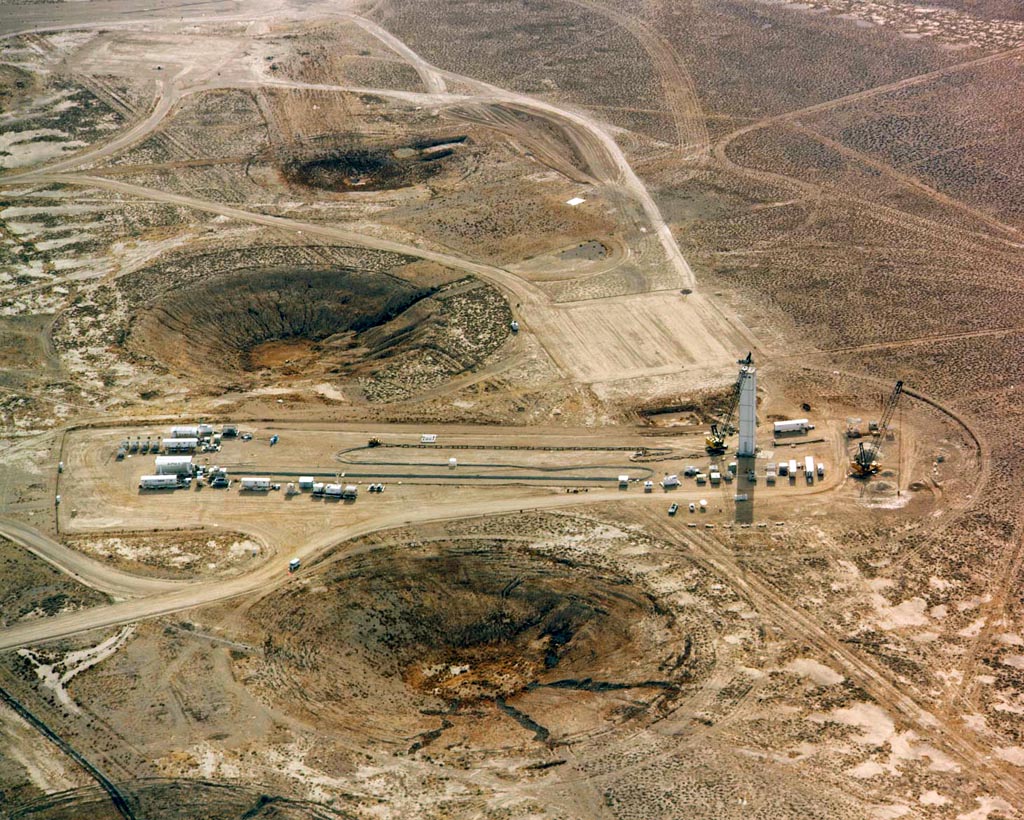
As of the end of 1992, there had been a total of 925 announced tests at NTS, 825 of them underground. This has left the Nevada Test Site pock-marked with subsidence craters, some of the more heavily used test areas are so heavily fractured that they are almost unusable for further testing.
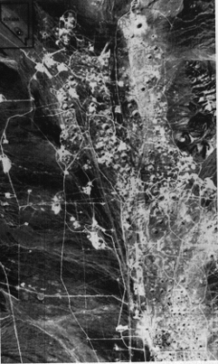 Satellite photo of NTS Craters from 438 miles up (45 K)
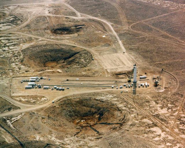
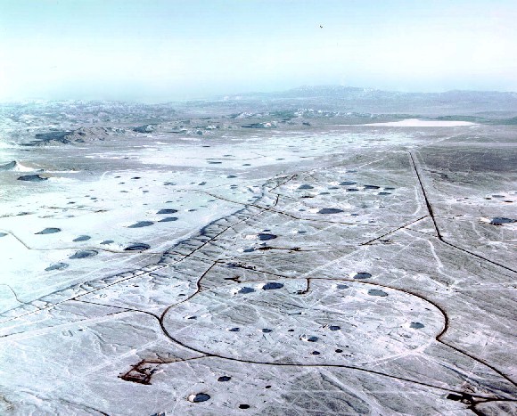 NTS Craters (102 K) |
 NTS Craters (141 K) |
 NTS subsidence craters (90 K); larger version (269 K) |
 Typical NTS subsidence crater (46 K); larger version (106 K) |
[Glasstone and Dolan 1977] Glasstone, Samuel and Dolan, Thomas. 1977. The Effects of Nuclear Weapons, USGPO.
[Knox 1969] J. B. Knox. 1969. A Heuristic Examination of Scaling UCID-15504, Lawrence Livermore National Laboratory. https://www.osti.gov/servlets/purl/461232-VJzMBZ/webviewable/461232.pdf
[Teller et al 1968] Edward Teller, Wilson K. Talley, Gary H. Higgins, Gerald W. Johnson. 1968. The Constructive Uses of Nuclear Explosives, McGraw-Hill Book Co., LC 68-11621.
 Sulky 640x489 (60 K)
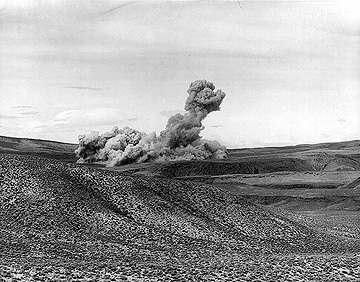 Buggy (57 K)
 Baneberry (68 K)
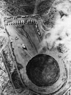 Huron King Crater (29 K)
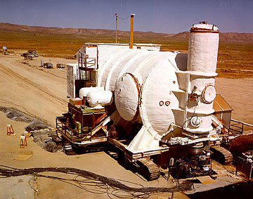 (28 K)
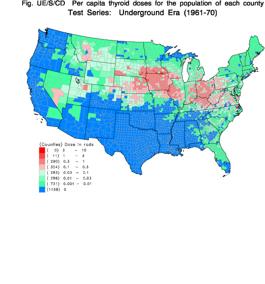